


le lâchât de Thônes

Louna
User

Length
7.9 km

Max alt
1996 m

Uphill gradient
978 m
Km-Effort
21 km

Min alt
1002 m

Downhill gradient
982 m
Boucle
Yes
Creation date :
2022-09-20 07:40:44.458
Updated on :
2022-09-20 11:25:55.07
2h36
Difficulty : Very difficult

FREE GPS app for hiking
 SityTrail
IGN / Geographical institutes
SityTrail Plus
The world is yours!
About
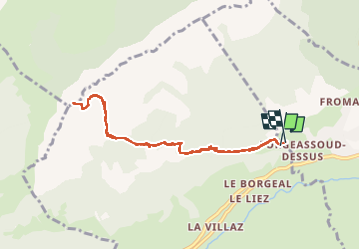
Trail Walking of 7.9 km to be discovered at Auvergne-Rhône-Alpes, Upper Savoy, Les Villards-sur-Thônes. This trail is proposed by Louna .
Positioning
Country:
France
Region :
Auvergne-Rhône-Alpes
Department/Province :
Upper Savoy
Municipality :
Les Villards-sur-Thônes
Location:
Unknown
Start:(Dec)
Start:(UTM)
297348 ; 5088779 (32T) N.
Comments